
Are we there yet?
This month we’ll take a journey around the ancient Mediterranean. Inside this issue: a human map of the Roman provinces, the wanderings of the heroes, fascinating online maps, ancient Roman travel mugs, the word “circumnavigate,” and more!
Email us to suggest a topic for a future issue!
![]()
Main Feature: Two New Lesson Plans
Each issue will feature two lesson or activity ideas: one related to the Latin language, and one related to Classical Studies (Greek or Roman culture, mythology, or history).
I. LATIN: HUMAN MAP OF THE ROMAN PROVINCES
Background: The various territories of the Roman Empire were divided into areas called provinces. These provinces were governed by men who had previously held high-ranking offices in Rome such as the consulship or praetorship. Before this lesson, it may be helpful to lead students in a discussion in which they consider how the Roman provinces were similar to our states. For example, both the Roman provinces and our states are components of a larger territorial unit, and both have governors.
Introduction: Students usually love to get out of their seats and move around the room. This activity, which appeals to a kinesthetic learning style, helps students to learn the names of major Roman provinces in a fun way!
Objectives: To learn the names of the major provinces of the Roman Empire as well as their locations in relation to one another.
Materials:
- Map of Roman Empire Slide (and LCD or overhead projector)
- Map of the Roman Empire handouts
- Signs with the names of the provinces
- Timer
Preparation by the Teacher:
- Write or type each province’s name on a piece of paper. Students will need to be able to read the signs from around the room, so the names should be large. Here is a basic list of provinces of the Roman Empire:
Aegyptus Āfrica Āsia Minor Britannia
Dācia Gallia Germānia Graecia
Hispānia Illyricum Ītalia Moesia
- Project the Map of the Roman Empire for students to see.
Procedures:
- Show students the projected map of the Roman Empire, and introduce them to the Latin names of the provinces. To encourage connections to prior knowledge about geography, ask students to tell you which modern countries are now located in the same areas as certain provinces (for example, France in place of Gallia, Spain in place of Hispānia, etc.).
- Have students label their own Map of the Roman Empire handouts.
- Practice the names and locations of the provinces by creating a “human map.” Give each student a Roman province sign, and ask the students to move around the room and arrange themselves in the correct locations in relation to one another. During this first attempt, keep the map projected for students’ reference.
- Ask students to trade province signs, and then repeat the human map activity for additional practice.
- Once the students begin to feel more comfortable with the material, use a timer and encourage the class to see how quickly they can create the human map. At this point, many students may no longer need to refer to the projected map, but it may still provide a necessary assistance for others.
- As an informal class assessment, have students do the human map activity without access to the projected map.
Special Concerns: If you have a large class with more students than province signs, split the class into two teams for the human map activity. Team 1 can do the activity, while Team 2 determines their accuracy and makes any necessary changes. Then the teams switch roles. The teams could also take turns racing to see who can complete the activity faster!
Additional Activity Ideas:
- To encourage the use of simple Latin commands, use yarn or tape to mark out roughly the shape of Italy and a few of the provinces on the floor. Then students can give each other simple commands, such as, “Nāvigā circum Siciliam” or “Nāvigā ad Hispāniam.”
- The class can cut-and-paste their own map of the Roman Empire using felt. Assign each student a province to cut from felt, and then have the students glue their provinces to a piece of posterboard or a large piece of paper.
- Another fun practice activity for learning the names of the provinces is the classic LatinSummer game, Roman Risk. Tape a white shower curtain to the wall, and then project a Roman Empire map onto it. Trace the map onto the shower curtain using a marker. Then divide the class into two teams, and explain that the goal is to win the most provinces. Team 1 announces the province it would like to conquer, and then both teams roll dice. If Team 1 rolled higher, it conquers the province. Then Team 2 announces a province it would like to conquer, and play continues until all provinces have been claimed.
II. MYTHOLOGY: THE WANDERINGS OF HEROES
Background: The tales of Odysseus and Aeneas both take place in the years following the Trojan War. Many students are familiar with the story of Odysseus and his ten years of adventures on his journey home. However, fewer students know of Aeneas and his long journey to Italy, where he founded a new home for the Trojan survivors. By examining both of these heroes’ travels, students can learn a great deal about Mediterranean geography!
Introduction: This lesson helps students to learn about various places around the Mediterranean through the exploration of two heroes’ mythological journeys.
Objectives: To compare and contrast the locations visited by Odysseus with the locations visited by Aeneas.
Materials:
- Access to a computer lab or a computer with an lcd projector
- Copies of a blank map of the Mediterranean
- Copies of the Wanderings of Aeneas Map
- Copies of a Venn diagram worksheet such as the one found here
Procedures:
- Students explore the story of Odysseus using this fantastic interactive map. They could do this in pairs in a computer lab or as a whole class using a projector.
- Students then use a blank map to draw a line for Odysseus’ course and then draw a symbol to represent each adventure in its correct location. For example, they might draw a stick-figure of a horse at Troy, and they might draw a lotus plant at the Island of the Lotus Eaters. Here is a suggested list of adventures for students to include:
Troy Island of the Lotus Eaters Island of Polyphemus
Aeolia Circe’s Island The Underworld
The Sirens Scylla and Charybdis Cattle of the Sun God
Calypso Ithaca
- Next, give students the Wanderings of Aeneas Map, and tell the class the story of Aeneas’ journey. Focus the story on the locations listed below (in chronological order) and on what happens to Aeneas in each location.
Troy Thrace Delos Crete
Buthrotum Etna Drepanum Carthage
Eryx Cumae Latium
It could be helpful to have some teacher notes. Bucknell University has a detailed summary of the story. Alternatively, teachers could read these episodes aloud from an appropriate-leveled children’s version of the story. We have not had the opportunity to explore any such books, but the right book could be a great way to bring the story to life!
- Have students come up with a symbol for each place Aeneas visited, just as they did for Odysseus’ adventures, and draw each symbol on the map.
- Have students examine the maps and complete a Venn diagram to compare and contrast the journeys of the two heroes. Then hold a class discussion about the students’ findings. Among other things, many students will find it interesting that both heroes encountered the lair of the Cyclopes!
![]()
Online Resource: Maps
Each issue will feature a new or popular online resource that could prove useful for Latin and Classical Studies instruction. We aim to stay current so that you can wow your students with how “with-it” you are when it comes to technology!
In this issue, we have two online resources to share!
- This map comparing the size of the Roman Empire to the size of North America can help students to get a sense of how vast the Roman Empire was. Since many students are already familiar with the size of North America, the map provides a useful comparison. As they examine the map, students can be encouraged to consider how difficult it was to manage such a large empire without the Internet, telephones, cars, or other modern technology. Teachers can also encourage students to use Latin words such as mare (sea) and terra (land) when examining the map.This map was found on a webpage called 40 maps that explain the Roman Empire. Teachers themselves may find the other thirty-nine maps helpful and fascinating, as they present cultural and historical information about Ancient Rome in chronological order via attractive maps. Be aware, however, that the webpage is not appropriate for children; it contains a photo of a sexually-explicit wall painting from Pompeii.
- More advanced students might enjoy experimenting with Stanford’s Orbis, an online tool that allows users to select and examine routes from one ancient city to another with various preferences such as season and mode of transportation. The site can calculate the distance and the duration of the journey as well as the cost. Students (and teachers!) could spend hours playing with Orbis.
![]()
Holiday: Iēiūnium Cereris
Each issue will feature an upcoming holiday from ancient Greek or Roman culture that you may wish to explore with your students.
The Iēiūnium Cereris, or “Fast of Ceres” was held on October 4th. Romans would fast in honor of Ceres, who was the goddess of grain and the harvest.
Ask students whether they celebrate any holidays involving fasting, and in what ways they celebrate fall. Many American students will recognize that we perhaps go to the opposite extreme– eating big meals on Thanksgiving to celebrate a good harvest! Thanksgiving can be a difficult holiday to celebrate in the Latin classroom because so many foods eaten were not known by the Romans, but this connection to harvest rituals is a nice way to draw connections between ancient and modern cultures.
![]()
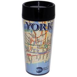
Random Find: Ancient Roman Travel Mugs
Many items being sold today do not directly connect to Latin and Classical Studies, but with a little effort, we can adapt them to serve our purposes. This section explores these types of objects.
Ancient Roman cups were not so different from what you might buy today. These cups contain information about how to travel from one area in the Roman Empire to another. They serve both as travel mugs and maps!

After examining the cups in the picture, students can make their own versions of these cups. Give students paper cups and have them draw the route they take to school. Alternatively, have students write directions in Latin on a paper cup in order to guide a traveler from one ancient Roman colony to another. For example: “Migrā ē Germāniā, per Helvēticam, ad Galliam.”
How we found them:
The cups were on display at Palazzo Massimo Museum in Rome, and they reminded The Shooting Star writer Skye Shirley of the subway mugs on sale in Boston and New York.
![]()
Featured Word: circumnavigate
Each issue will feature a challenging English word that we encourage you and your students to explore together. The English word will always come from one or more Latin words.
The Latin word “nauta,” which means “sailor,” has many English derivatives. Ask your students to brainstorm as many “naut-” words as they can, and then move them to the Latin word “nāvigāre,” which means “to sail.” The word “circumnavigate” is very Latin-based, and means “to sail around.”
Then have them imagine their own derivatives which use Latin words. For example, maybe “circumastronaut” is an astronaut who circles the moon. Or “tyrannonaut” is an evil sailor.
While you’re discussing these sea-travel words, students might also enjoy this additional connection: The Latin word for seasickness, “nausea,” is at the root of our word “noise.” At first, “noise” meant a general sense of discomfort, reflecting its seasickness origin. Only later did it come to refer to any sound, whether unpleasant or not.
![]()
Advice & Questions:
How can I get my students looking at maps from Day 1?
Students can look at a map and say “Ubi est?” and “Est in… + ablative” to construct simple Latin sentences and practice place names. This could be a fun partner activity in which each pair is given a map and some kind of character prop, such as a small action figure that can stand on its own. One student places the prop and then asks, “Ubi est [puella]?” The partner responds in Latin with “Est in…+ ablative.” For an added challenge, they could use “sunt” to describe multiple items in a place. It’s okay if the students use labeled maps; looking at the place names will help them to learn!
You can also send students on a scavenger hunt to find the locations of Roman cities and label them on a map.
Comments are closed